While the Commonwealth of Pennsylvania is now home, I was blessed to grow up in Northern California. A fortunate component of these formative years were occasional opportunities to visit Yosemite. So, finally, I found the time, in June 2017, to bring Mrs Bear to this cathedral. But before writing about this visit, we began our trip with a visit to Lake Tahoe.
 We began by flying into Sacramento Airport (SMF)… Sacramento is centrally located to all we were to do and it affords better on-time reliability and cheaper rental car prices. Although we didn’t take advantage, a traveler can visit the sight of gold discovery on the American River. Instead, we spent a late night at a nearby hotel and headed up the I-80 grade to Tahoe.

But before the drive, we stopped at “The Waffle Experience.” Only in California…
The drive toward Tahoe is uneventful until the option appears to exit for Donner Pass. Hopefully, most of my dear readers recall the fate of the Donner Party, who became stuck in deep snow and endured a fateful winter waiting for the snow to melt. This diversion gives the traveler a glimpse of the natural beauty of the pass that killed many of them. Today, it is a Mecca for bikers, pilgrims like me, and campers. I hope the picture does it justice…

After driving through Donner Pass, the road brought us into Truckee, California. Truckee used to be a sleepy, gateway town to the ski areas on the California side of Lake Tahoe. But it has grown, and I really haven’t been here in a couple decades (or longer). AND it was Memorial Day weekend. We drove through Truckee and along the western shore of Lake Tahoe…
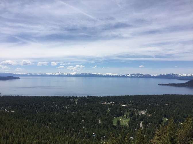
Tahoe is a beautiful, blue, alpine lake at roughly 6200 feet above sea level. We stayed on the south shore, very near the border with Nevada. This made the human traffic even zooier…For example, it was near impossible to park anywhere along the lake on the ride in. However, the next day was Memorial Day, and loads of people packed up and headed back down to the Bay Area. This is when our trip really began.
Mrs Bear does not like to be confined to a car for more than a day at a time. So she rented a bicycle and had a wonderful day on the multiple bike paths. I took my sister and brother-in-law on a driving tour of the surrounding mountains. We started by driving east along the flank of Mount Rose towards Reno. Mount Rose was having their last day of ski season, and we were told that, at the height of winter, the snow was plowed eight feet high on both sides of the road. Instead of turning toward Reno, we ventured south toward the western town of Virginia City.
The first thing you get used to in these historic area is that there are no bars…There are instead, saloons. And they all seem to have a history. For example, the first one we visited had a dead man’s poker table. It seems that many men lost their fortunes betting here and took their own lives when they became penniless. 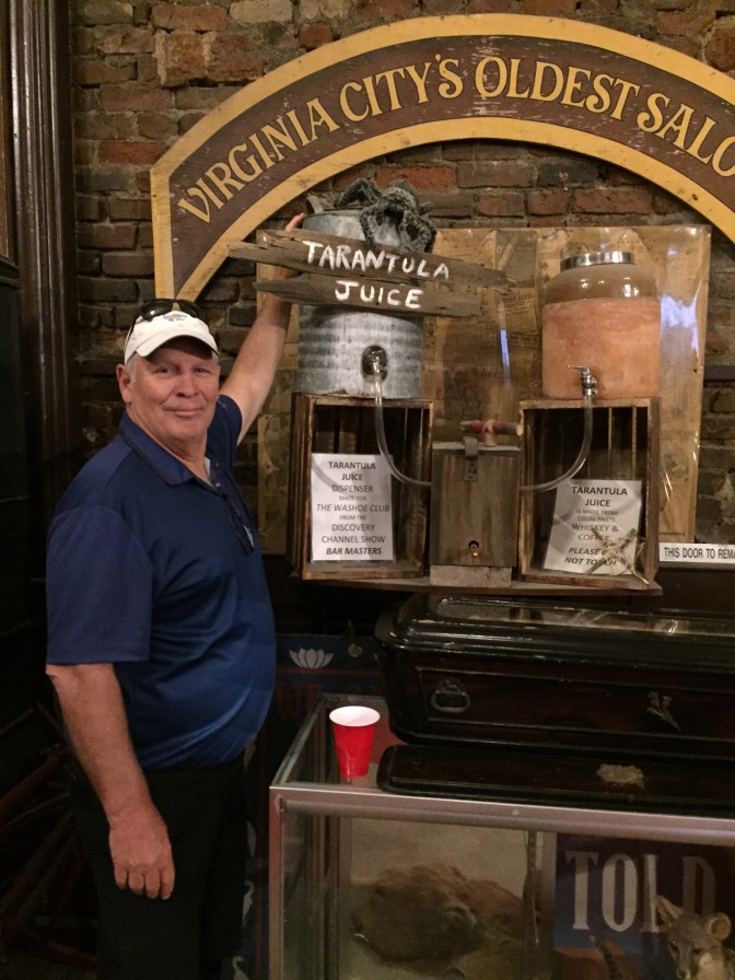
I wasn’t drunk enough to order this local brew…
Next, we moseyed down the street to a saloon that featured the historic “Millionaires Club.” The history is that there was a spiral staircase in the back that led to a private club. Dues to join was $1,000,000. We wanted to tour, but would have had to wait for three hours. Instead, we bought a non-tarantula brew and were allowed to walk to the base of the stairwell and view the Crypt. This is a cold, brick room with no windows where bodies were stored. today, there is a meter that monitors ghost “activity.


I was actually more enthralled with the whole idea of a Millionaires Club…Reportedly Samuel Clemons was a member. BUT, how much money was this in the 1800s to pay for membership, and God only knows what services were up those stairs. I guess we had to go on the tour to find out what they got for their money !!!
We left Virginia City behind and drove through a couple more old mining towns before heading over the pass back to South Lake Tahoe. One particular saloon was recommended to us…It was Nevada’s oldest bar.
I don’t recall the name or town, but the bar itself was marked with many burns. The story goes that cowboys would spill the booze on the bar and attempt to light it. If it caught fire, the whiskey was sufficient alcohol proof and left a mark in the bar. This way, the customers could tell if they were being ripped off with watered-down booze. I assume people didn’t life very long in those times !!!
YOSEMITE
The ride was the better part of five hours due to the continued closing of the closest entrance. Once again, Tahoe is at about 6200 feet above sea level…The valley floor in Yosemite is about 4200 feet. And the high pass road, through the Toulumne Meadows rises above 8000 feet. This pass is usually closed into mid summer, and this year, there was no telling when it would open. So we took the long way around, but the scenery was outstanding and no one complained, as long as the driver stayed clear of the narrow shoulders with no guardrails.
And then all of a sudden, there is your first glimpse. I hope you have been to a vista where you remember the first glimpse…I recall the Grand Canyon, New York City skyline, and Mount Rushmore this way. Those initial views are forever etched on your brain…And Yosemite will also be eternally remembered.


And then you get closer…You realize that Yosemite is a cathedral, chiseled by the Merced River and receding glaciers…And God discovered his majestic work as well. I believe God resides in Yosemite when she visits North America.
A couple more photos of Yosemite from Glacier Point…Behind Lela is Yosemite Falls. Dani and I hiked to the top during my last visit, approximately 10 years ago. Behind me is Half Dome, the most challenging day-hike in Yosemite. The best place to attempt this all-day endurance challenge starts from this vantage point. Down a few thousand vertical feet before starting the hike up the granite…Don’t get caught anywhere near the Hald Dome summit with lightning in the forecast. And one more observation…Can you imagine the size and power of the glacier that carved off half of this incredible dome that, today, reaches a summit of 8200 feet ??? I rally Can’t !!


All good things end, and so we had to leave Heaven in California and head to our last destination: Half Moon Bay. This is a small town on a crescent – shaped bay 28 miles south of San Francisco. In my youth, we drove through Half Moon Bay on Highway One on our way to Santa Cruz to bodysurf in slightly warmer water with bigger waves and a boardwalk amusement park to visit afterwards. Lela and I later found that Half Moon Bay was a great place to visit if we flew back east from SFO in the late afternoon, We played golf at their beautiful links course, ate a late lunch, and drove about ten miles over the ridgelines to the airport, which is located south of the city. So I picked Half Moon Bay this time for its beauty and location…As a base, we could travel south to Monterey, or north to the City or Marin County. We ended up doing both from a beautifully located small inn on the bay. We were able to walk their bike path to dinner every night at a different local seafood restaurant. Here is my lovely wife and her sister walking the coastline path to dinner.

Mrs Bear hates to travel in a car on consecutive days…So we left her to hike the local paths in Half Moon Bay, while I entertained our kin with a trip to Seventeen Mile Drive in Monterey. If you have never been to this seacoast bay, made famous by California history and the books of John Steinbeck, a visitor can stay for a couple nights, stroll the marinas of Monterey and Carmel, go out whale watching, and visit the aquarium. Naturally, the food is great: fresh crabmeat and sourdough bread from SFO. And it goes without mentioning that the wine and beer is world class. We drove through the seaside with a stop for lunch at Barbara’s request: In and Out Burger, which she says was quite the spot for celebrities after the Oscar presentations.
Seventeen Mile Drive is a toll road that meanders along the coast for most of its length. Outside of Scotland, this drive lets one see glimpses of seven famous golf courses, highlighted by Pebble Beach and Cypress Bay. The houses are fantastic and the coastline is California craggy. All-in-all, a great day: 
On the way back, we drove back up the Coast Highway to Santa Cruz. This oceanside town played a significant role in my childhood for a number of reasons, especially the carnival rides on the boardwalk. Some of you may remember this park being featured in the Clint Eastwood, “Harry Callahan,” movie SUDDEN IMPACT. While the movie town was called “San Paulo,” it was filmed in Santa Cruz. We drove in but had trouble parking, and discovered that the pier had grown into a much more diverse attraction with a huge crowd. So we settled for walking an adjacent pier and seeing Santa Cruz from a distance. The seals below kept us company,


So, what do we do with our last day before flying back to the right coast ?? We started by driving north on the Coast Highway into SFO…Next stop, the Golden Gate Bridge. We let Mrs Bear and brother John out on the San Francisco side to begin walking. Sister Barbara and I parked the car at the northern scenic lookout and began walking back toward SFO. We met in the middle. My picture with the Marin County sign is actually on the bridge at the point where we leave the City and cross over into the Promised Land. The other photo is Angel Island, now a State Park in San Francisco Bay.


This might seem like the perfect final experience, but no !!! Driving into Mill Valley, my hometown, we drove up the flank of Mount Tamalpais to Muir Woods. I dropped Mrs Bear off and she hiked into Muir Woods. We drove down and went into this redwood tree vista the conventional way. Muir Woods is a National Monument with includes the largest redwood tree groves close to SFO. It is a “must see,” if you visit the most beautiful city in the USA. I took this park fro granted for a long time…I only had to look out my window as a child to see an obstructed view from the redwood tree in my yard. But I always knew how fortunate I was to grow up in this natural setting 12 miles from San Francisco.


The next photo is a cross section of a tree that fell down many years ago…They have marked various historical events on its rings to demonstrate the tree’s remarkable age

We left the next morning, but my guests, who had allowed me to showcase the California of my youth, were very impressed. I’d like to come back with Mrs Bear again, and perhaps visit Yosemite in winter !! Keep checking in to see if we make it.


